Raivavae, Austral Islands
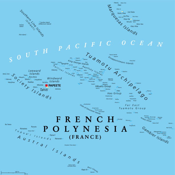
The Austral Islands are the southernmost group of islands in French Polynesia, an overseas country of the French Republic in the South Pacific. Geographically, they consist of two separate archipelagos, namely in the northwest the Tupuai islands consisting of Maria Island, Rimatara, Rūrutu, Tupuai Island, and Raivāvae, and in the southeast the Bass Islands composed of the main island of Rapa Iti and the small island Marotiri.
Rurutu was the first of the Austral Islands to be discovered by Europe in 1769. James Cook reached the island, which he named Ohetiroa, during his first voyage to the Pacific on August 14, 1769. After HMS Endeavour anchored off the island for the night, Cook launched the Pinnace the next day under the command of Lieutenant Gore.
James Cook discovered the island of Tubuai in March 1777 during his third voyage, but failed to set foot on the island. His report was known to Fletcher Christian, the leader of the mutineers on HMS Bounty. After the mutiny of the Bounty on April 28, 1789, off Tofua, the ship first headed for Tubuai, but only stayed there for a week before sailing for Tahiti. Armed with provisions and several Tahitian women, the mutineers returned to Tubuai to settle. However, internal disputes and bloody clashes with the islanders, in which 66 Tubuans were killed, caused the Bounty to depart only three months later.
Whaling vessels were among the earliest and most consistent visitors to the islands in the 19th century. The first such vessel for which a record exists is the New Hazard in 1813. These ships came for fresh drinking water, firewood and food provisions.
In 1862, a two-year incursion of the so-called “Blackbirders” began, who took more than 3500 South Pacific islanders to Peru and Chile as slave labor. In December 1862, a fleet of five ships anchored in Rapa’s Ahurei Bay. A strong group of armed men was put ashore to capture workers by force. But the inhabitants retreated to the mountain forts and the occupants had to leave without having achieved anything. A few days later, the Chilean schooner Cora arrived at Rapa. Thirteen chiefs met and decided to capture the ship and crew and hand them over to the French authorities in Tahiti. A group of warriors sneaked aboard the Cora and seized the captain. The crew surrendered without resistance. Five sailors decided to stay on the island as guests. A subsequent attempt by the barque Misti to capture the work was abandoned when the captain learned of the Cora’s fate.
The 6,820 inhabitants of the Australs live mainly in small villages; there are no large cities in the Austral Islands. Unlike other regions of Polynesia, the population of the Austral Islands has declined since the mid-1990s. The reason is the high migration of young people from the isolated archipelago to other parts of Polynesia or to France for their better job prospects.
The majority of the population is Christian mostly belonging to various Protestant groups and the Catholic Church.
Raivavae Island
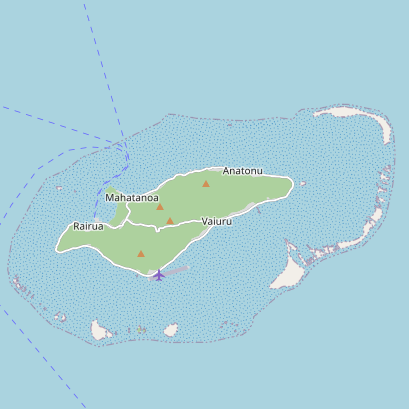
Raivavae is one of the Austral Islands in French Polynesia. Its total land area including offshore islets is 6.9 sq miles. At the 2017 census, it had a population of 903. The island is of volcanic origin, and rises to 1,434 ft elevation at Mont Hiro.
The first sighting of Raivavae by Europeans was recorded by the Spanish naval officer Tomás Gayangos on board of the frigate El Aguila on 5 February 1775. Gayangos had taken over the command of the expedition of Domingo de Bonechea of 1774 after his death in Tahiti and was returning to the Viceroyalty of Peru. The main source describing this sighting is that of José Andía y Varela, pilot of the packet boat Jupiter that accompanied El Aguila in this return trip. On 6 February, a boat was sent in, and made contact with the inhabitants at the shore edge, but landing was not made. Raivavae was charted as Santa Rosa by the Spaniards, who recorded as Oraibaba the name of the island said by the inhabitants.
Raivavae was annexed by France in 1880.
The islands of Raivavae are administratively within the commune with the same name. Raivavae consists of the following associated communes: Anatonu, Rairua-Mahanatoa, and Vaiuru.
The island of Raivavae lies at the coordinates of 23°52′00″S and 147°40′00″W.